What does a surveillance state look like?
Over the past eight months, classified documents provided by NSA whistleblower Edward Snowden have exposed scores of secret government surveillance programs. Yet there is little visual material among the blizzard of code names, PowerPoint slides, court rulings and spreadsheets that have emerged from the National Security Agency’s files.
The scarcity of images is not surprising. A surveillance apparatus doesn’t really “look” like anything. A satellite built by the National Reconnaissance Office (NRO) reveals nothing of its function except to the best-trained eyes. The NSA’s pervasive domestic effort to collect telephone metadata also lacks easy visual representation; in the Snowden archive, it appears as a four-page classified order from the Foreign Intelligence Surveillance Court. Since June 2013, article after article about the NSA has been illustrated with a single image supplied by the agency, a photograph of its Fort Meade headquarters that appears to date from the 1970s.
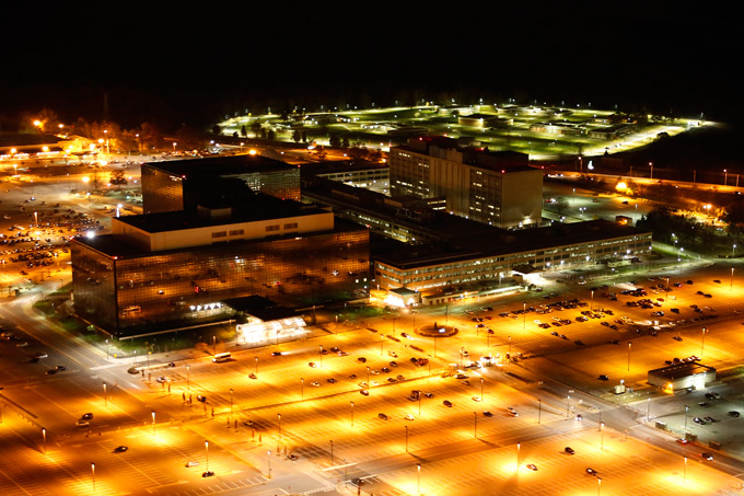
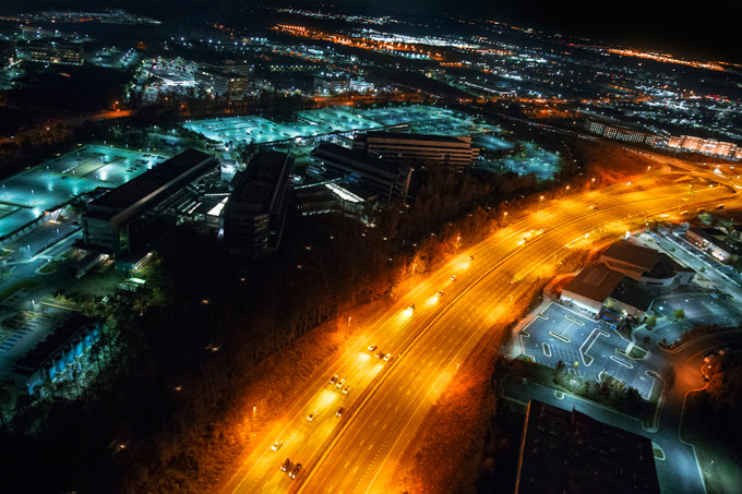
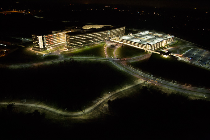
The photographs below, which are being published for the first time, show three of the largest agencies in the U.S. intelligence community. The scale of their operations were hidden from the public until August 2013, when their classified budget requests were revealed in documents provided by Snowden. Three months later, I rented a helicopter and shot nighttime images of the NSA’s headquarters. I did the same with the NRO, which designs, builds and operates America’s spy satellites, and with the National Geospatial-Intelligence Agency (NGA), which maps and analyzes imagery, connecting geographic information to other surveillance data. The Central Intelligence Agency—the largest member of the intelligence community—denied repeated requests for permission to take aerial photos of its headquarters in Langley, Virginia.
My intention is to expand the visual vocabulary we use to “see” the U.S. intelligence community. Although the organizing logic of our nation’s surveillance apparatus is invisibility and secrecy, its operations occupy the physical world. Digital surveillance programs require concrete data centers; intelligence agencies are based in real buildings; surveillance systems ultimately consist of technologies, people, and the vast network of material resources that supports them. If we look in the right places at the right times, we can begin to glimpse America’s vast intelligence infrastructure.
These new images of the NSA, NRO and NGA are being placed in the public domain without restriction, to be used by anyone for any purpose whatsoever, with or without attribution. They can be found on Creative Time Reports, which commissioned this piece, as well as on Flickr, Wikimedia Commons and The Intercept.
Download high resolution images of these photos: NSA, NRO, NGA

NATIONAL SECURITY AGENCY (NSA)
With a 2013 budget request of approximately $10.8 billion, the NSA is the second-largest agency in the U.S. intelligence community. It is headquartered in Fort Meade, Maryland.

NATIONAL RECONNAISSANCE OFFICE (NRO)
The NRO is in charge of developing, deploying and operating reconnaissance satellites. With a budget allocation of $10.3 billion, it is the third-largest U.S. intelligence agency. Its headquarters are in Chantilly, Virginia.

NATIONAL GEOSPATIAL-INTELLIGENCE AGENCY (NGA)
The NGA is responsible for collecting, analyzing and distributing intelligence derived from imagery. According to documents provided by Edward Snowden, the NGA’s latest budget request was $4.9 billion—more than double its funding a decade ago. It is headquartered in Springfield, Virginia.
This piece was produced in partnership with The Intercept.

